"Good morning yesterday. You wake up, and time has slipped away. And suddenly it's hard to find, the memories you left behind. Remember. Do you remember?" - Paul Anka, Times of Your Life
Friday, August 30, 2013
Then and Now – Anamalai Avenue
Here are
two photos of Anamalai Avenue. The top photo is from the PictureSG website hosted
by the NLB. It is accompanied by the following explanation; “This 1993
photograph shows Bukit Timah Road, towards Anamalai Avenue (southwards).” Actually,
I think this explanation is incorrect. The photo actually shows Anamalai Avenue
towards Bukit Timah Road. You can refer to the second photo which was taken by
me earlier this month.
On the left
of this photo is the Royalville Condo. Beyond this is Bt Timah Rd and behind the trees is the Bukit Timah
Canal.
As you can
see, the old shops are all gone. In its place is a new building which houses a
branch of the OCBC Bank. Previously, the bank was located at the other end of
Sixth Avenue Centre, nearest to the traffic lights. Do you know what was the
name of this bank previously?
It was known
as Keppel - Tat Lee Bank. And before that, it was simply Tat Lee Bank.
From post: "NLB [...]: “This 1993 photograph shows Bukit Timah Road, towards Anamalai Avenue (southwards).” Actually, I think this explanation is incorrect. The photo actually shows Anamalai Avenue towards Bukit Timah Road."
I think you are spot-on ... I seem to see a road-turning signage in the LHS background of NLB's 1993 photo. In which case, the tall building beside the ramshackle shops would be the Sixth Ave Centre (completed: 1985) w/o the OCBD extension.
Here's a Google Street View vantage (beside Royalville Condo entrance along Anamalai Ave) that compares better with NLB's photo. It seems that between 1993 & the present day, this stretch of Anamalai Ave had shrunk from almost 2 car-widths each way to strictly 1 car-width each way.
On the other hand, NLB's description appears to describe the alternative vantage point (Google Street View) along Bt Timah Rd, where a queue of cars are waiting alongside Sixth Ave Centre to turn into Anamalai Ave.
Comparing Google's Oct 2008 capture along Bt Timah Rd (at the Anamalai Ave turning) with your recent photo (with hoarding & some sort of facade banner), is the OCBC extension getting taller or having its facade refurbished ? Any idea when this structural extension was built ?
Btw I came across these NHB PICAS photos showing Anamalai Ave as a rocky dirt track back in 1959 -- funeral pall-bearers & mourners were walking towards a certain Chye Teng Teoh Cemetery when they were waylaid by more than 50 gangsters: Funeral Part Ambushed (ST - 25 Jan 1959). Ever come across any remnants of the said cemetery along/ near Anamalai Ave ?
Pat. For your info, those cars along BT Rd are not waiting to turn into Anamalai Ave. They are parked/waiting illegally while the owners do their business in the OCBC bank.
Although I travel here frequently, I cannot remember exactly which year the OCBC branch was built. Probably 7 or 8 years ago. The hoarding in front of the bank is just part of the finishing touches to the new bldg; probably the steps.
Thanks for that link to the interesting ST article and photos of the Anamalai gang fight/ambush of 1959. Throws some light on the geography of that area that is worth further study.
Photo of me and my dog Nappie from my kampong days (around 1967 or 68)
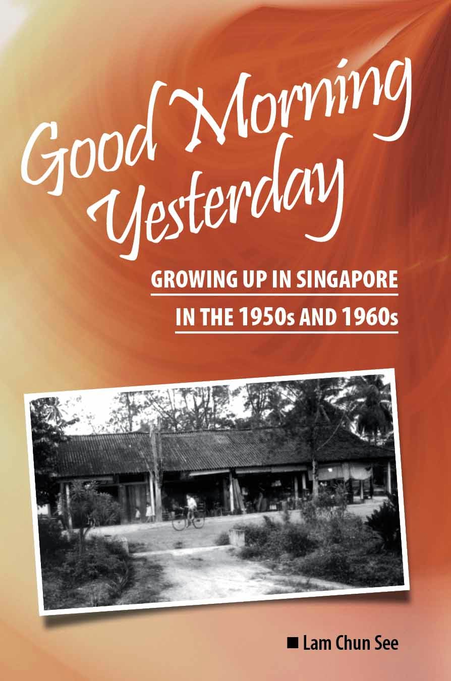
My book
Dear friends. If you’re in Singapore, you can purchase my book Good Morning Yesterday directly from me at only S$12.50. Message me with your mailing address and I will send the book to you. You can pay via Paylah or Pay Now. Thank you.
Good Morning Yesterday (Book)
Please visit our Facebook Fan Page. Click on photo.
“We have to tell the Singapore story …. Parents and grandparents have a role to play. You have to tell the stories to your children, to your grandchildren to know not only what happened but how you feel about it.”– PM Lee Hsien Loong at 2006 National Rally.
Testing new post
-
1. Anyone who wants to follow Jesus must be prepared to declare
like the Indian villager behind the song “I have decided to follow Jesus”
(I ...
.jpg)
+copy.jpg)
.jpg)


2 comments:
From post: "NLB [...]: “This 1993 photograph shows Bukit Timah Road, towards Anamalai Avenue (southwards).” Actually, I think this explanation is incorrect. The photo actually shows Anamalai Avenue towards Bukit Timah Road."
I think you are spot-on ... I seem to see a road-turning signage in the LHS background of NLB's 1993 photo. In which case, the tall building beside the ramshackle shops would be the Sixth Ave Centre (completed: 1985) w/o the OCBD extension.
Here's a Google Street View vantage (beside Royalville Condo entrance along Anamalai Ave) that compares better with NLB's photo. It seems that between 1993 & the present day, this stretch of Anamalai Ave had shrunk from almost 2 car-widths each way to strictly 1 car-width each way.
On the other hand, NLB's description appears to describe the alternative vantage point (Google Street View) along Bt Timah Rd, where a queue of cars are waiting alongside Sixth Ave Centre to turn into Anamalai Ave.
Comparing Google's Oct 2008 capture along Bt Timah Rd (at the Anamalai Ave turning) with your recent photo (with hoarding & some sort of facade banner), is the OCBC extension getting taller or having its facade refurbished ? Any idea when this structural extension was built ?
Btw I came across these NHB PICAS photos showing Anamalai Ave as a rocky dirt track back in 1959 -- funeral pall-bearers & mourners were walking towards a certain Chye Teng Teoh Cemetery when they were waylaid by more than 50 gangsters: Funeral Part Ambushed (ST - 25 Jan 1959). Ever come across any remnants of the said cemetery along/ near Anamalai Ave ?
Pat. For your info, those cars along BT Rd are not waiting to turn into Anamalai Ave. They are parked/waiting illegally while the owners do their business in the OCBC bank.
Although I travel here frequently, I cannot remember exactly which year the OCBC branch was built. Probably 7 or 8 years ago. The hoarding in front of the bank is just part of the finishing touches to the new bldg; probably the steps.
Thanks for that link to the interesting ST article and photos of the Anamalai gang fight/ambush of 1959. Throws some light on the geography of that area that is worth further study.
Post a Comment